Leaflet plugins
Leaflet is a modern JavaScript library for interactive maps supports WMS, GeoJSON and Tile layers natively.
Many other types of layers and widgets are supported via plugins.
- Leaflet Search
Control for searching markers and features by custom fields from layer or remote source.
- Leaflet Panel Layers
Leaflet Control.Layers extended for multiple layers groups and icon legends.
- Leaflet JSON Layer
Build dynamic JSON Layer via Ajax/JSONP with Caching requests.
- Leaflet Gps
Simple Leaflet Control plugin for tracking gps position, highly customizable.
- Leaflet Compass
Leaflet Control plugin to make simple rotating compass.
- Leaflet GeoJSON Selector
Leaflet Control for select GeoJSON features/properties in a interactive menu.
- Leaflet Location Picker
Simple location picker with Leaflet map.
- Leaflet Loader
Simple control to show/hide a gif loader to the center of the map.
WebGIS projects
GeoPicker
Geospatial dataset picker via fast Api Rest interface written in NodeJs for GDAL bindings and Fastify
KeplerJs
The open source full-stack geosocial network platform.GPX Optimizer online
Online Simplifier and tracks Optimizer.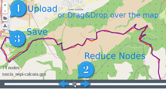
OpenValleyMap
The open geospatial database of boundaries and the toponymy of all the valleys in the Alps.Track GPS Network
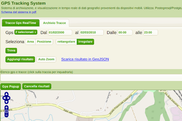
GPS tracking system of remote devices and tracks spatial search